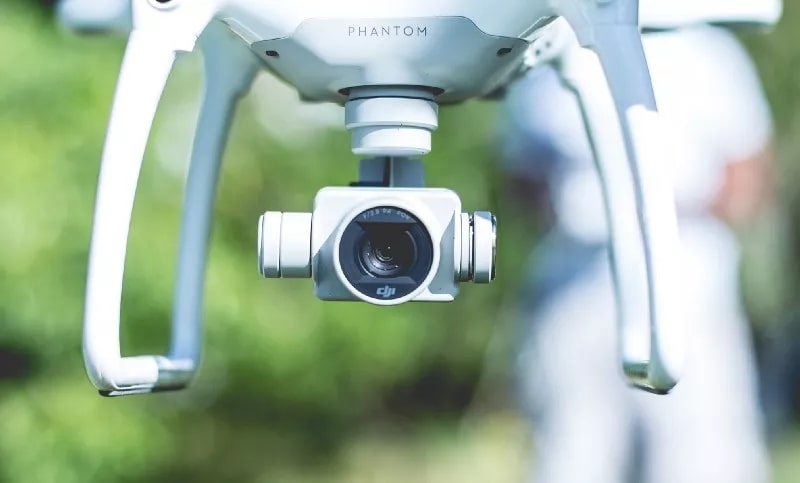
Interested in adopting a drone survey program to develop new efficiencies at your worksite? A successful drone program requires both high-quality software for drone mapping and a quality camera for collecting images and data.
If you’re launching a new drone program for your business, data processing solutions like Propeller Aero transform the data you collect in flight into 3D models you can use to track progress and make informed decisions in your day-to-day workflows. But you need a drone with the right camera to collect the data. Here’s a brief guide to how the camera you choose, and the settings you work with, can affect the quality of your drone surveying results.
About ground sample distance
Ground sample distance directly affects the quality of maps and models you get from drone surveys. It refers to the real-world size of a pixel in the images collected by drone. Ground sample distance is affected by the following variables:
· Altitude of image capture
· Camera resolution
· Camera aperture
· Camera sensor size
· Lens focal length
The type of camera in your drone directly affects the ground sample distance you’ll need to accurately survey your site. A lower ground sample distance is ideal. The following settings impact ground sample distance.
Camera resolution
This setting refers to the amount of pixels the sensor will map, and most drones on the market have a resolution that varies between 2-50Mp. If you invest in a drone with a higher-resolution camera, you can achieve a greater ground sample distance. Keep in mind, though, that higher camera resolutions don’t always make better surveys. Higher resolution with a small sensor can cause diffraction, making images less sharp and less useful.
Sensor size. When it comes to UAVs, you can choose among several standard sensor sizes, including 2/3”, 1”, Micro 4/3rds, APS-C, and full frame. Generally, larger sensors can gather light better at the same resolutions. If you invest in a drone with a smaller sensor, you need to account for longer exposure times to achieve a comparable image outcome.
Camera aperture
In any camera, aperture affects how much light reaches the sensor. Aperture values are marked with an “f,” and they directly affect the images the camera captures. Most UAVs feature low fixed aperture values, like f 2.0. It usually places an infinity focus region on all objects a few meters away from the camera, and low-resolution cameras can’t resolve points apart once the ground is too far away.
If you invest in a UAV that doesn’t have variable aperture, your camera has to extend exposure times, often resulting in blurry images. Adjusting aperture settings to match lighting conditions, effectively exposes the camera’s sensor so that it can capture sharp, high-quality images.
Diffraction is another consideration when it comes to aperture. If you fix the aperture in a small position with a high f-value, and if the pixels are small, diffraction will reduce the overall sharpness of the images you gather. Diffraction will make light fall on multiple pixels, reducing the overall sharpness of each image—when surveying with a drone, you need sharp images with defined pixels to create accurate, useful 3D point cloud models.
Focal length
Focal length refers to a combination of sensor size, an appropriate distance from mirrors within the lens, and the curvature of the glass. Today’s drones are equipped with a focal length between 10mm to 1200mm. Generally, long focal lengths have lower resolution, while shorter focal lengths are ideal for surveys.
Camera considerations for inspections
If you’re flying a drone to conduct asset inspections, the camera you’re using makes a big difference in the quality of data you get from surveying. You need to have a high resolution camera with a larger sensor and a 35mm equivalent focal length. Investing in the right camera allows you to gather more details about any point of any object you’re inspecting. It also allows you to increase image contrast, so your drone data can be used to make accurate 3D models and point clouds.
You should also consider camera articulation when you’re using drones for inspections. When inspecting objects like a bridge or overpass from below, ensure that the gimbal is fully articulated so the camera can be pointed in all directions. If you frequently inspect items from below, it’s wise to invest in a larger drone like the DJI M100 or M600 which have fully articulated cameras that are ideal for inspecting points from below.
Autofocus is yet another important consideration for inspections. The best camera for the job has quick autofocus and short focal length—when you’re flying above 20m, all objects will be in the infinite focus region. By keeping the site in focus, the camera won’t have to add more focal points which can often result in blurred images.
Camera considerations for surveys
Many of the camera considerations for surveys are the same as they are for inspections. The higher resolution and larger sensor size your camera has, the better your results will be. Since higher resolution cameras allow for a higher ground sample distance, you can fly your drone higher and achieve the same quality results. This is especially beneficial when high levels of interference on the ground exist.
If you plan to regularly use a drone for surveying, choose a model with a camera that has a mechanical shutter. They reduce the rolling shutter effect that occurs with fast motion and often causes heavy distortion to the images. Cameras with a mechanical shutter produce higher quality images, which lead to more accurate 3D models.
It’s not all about the drone
If you’re planning to adopt a drone survey program for your worksite, keep in mind that choosing the right drone with the right camera is only one part of the process. Choosing the right drone data processing software is just as important. Propeller’s cloud-based processing platform transforms the data you collect by drone into reliable, accurate 3D models that enable better decision making at any jobsite, from civil construction and earthworks projects to landfills and quarries.









Leave a Reply